Kings Canyon NT
KINGS CANYON RIM WALK
Kings Canyon rim walk in Watarrka National Park is one of my favourite walks. The walk ascends to the top of the canyon and follows the canyon rim around until it descends to the car park. I have seen pictures of this spectacular place and I was really excited to be there, and the real canyon did not disappoint.

We stayed overnight, close by at Kings Canyon Resort, so we could get an early start.
We got to Kings Canyon car park the following day and we realised that we didn't have an early start. Tour buses had already arrived and a lot of people had started the walk.
The temperature of the day was mostly sunny with a comfortable low 20°C. However, the walk was very exposed and under the sun you heat up really quickly. Adequate water supply is very important.
Near the car park, there were flush toilet, drinking water supplies, information board, seating areas, and even wifi spots.

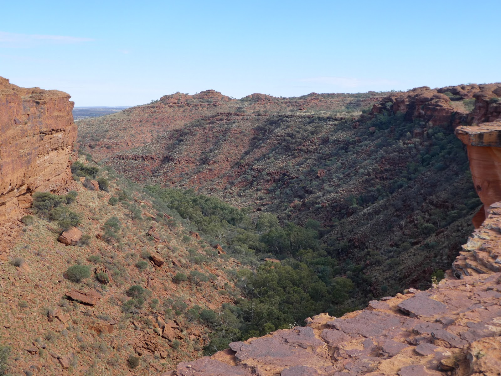
After a short walk from the car park, we turned left at the intersection and started the steep climb up the hill, sometimes called Heart Attack Hill, to the top of the canyon. Although it was steep but the rocks were carved into stairs so it wasn't difficult, only tiring. We stopped a few times to turn around and enjoy the magnificent view and to appreciate how much we have climbed up.


Once we got to the top, we knew the hardest part was behind us and it was time to explore.


We came across this sign on the side which headed to one of many breathtaking scenic lookouts, Cotterill's Lookout. I highly recommend taking this side track.


We then continued our walk to the staircase where we walked down and crossed a footbridge.

Before heading up the staircase on the opposite side, we detoured down to Garden of Eden. Look out for the signage as it can be easily missed. Garden of Eden was not too far and it was really worth the extra 600m return. It was like entering a little hidden paradise with a beautiful waterhole. The place was cool and shady, compared to the very exposed track on top of the canyon. The water was so still that it created a mirror image of the cliff above it. The place was peaceful and calm, even with quite a few people around. A great location to take a break and eat lunch or snacks.


After a nice snack break, we walked up the staircase into the sun, and continued our rim walk towards the South Wall.
There was a lookout where you could see the perfectly straight cliff face on the opposite side, like a sharp knife had cut the cliff vertically down.


There were lots of cool beehive-like sandstone domes along the way which gave the "lost city" feel.


There were a few helipads, emergency radio call devices (ECD), and automated external defibrillator (AED) for emergencies. I wonder how often they needed to be used.


Finally we descended on the edge of the south wall to the car park. The track was very scenic and we got to see the other side of the canyon.

We bumped into this little fellow, having a sun bake in the afternoon.

Total distance: 6km

Total distance: 2.6km return
Climb:50m
KATHLEEN SPRINGS WALK
On the way driving to Yulara for our next stay, we stopped at Kathleen Springs for a walk. The walk was 2.4km return to a spring fed waterhole. There were signs along the way that told stories of Aboriginal culture and the cattle industry.
It was an easy, relaxing, paved walk. It was also wheelchair accessible and a good walk for less mobile persons.


Total distance: 2.4km return
Climb: 60m
Kings Canyon rim walk in Watarrka National Park is one of my favourite walks. The walk ascends to the top of the canyon and follows the canyon rim around until it descends to the car park. I have seen pictures of this spectacular place and I was really excited to be there, and the real canyon did not disappoint.

We stayed overnight, close by at Kings Canyon Resort, so we could get an early start.
We got to Kings Canyon car park the following day and we realised that we didn't have an early start. Tour buses had already arrived and a lot of people had started the walk.
The temperature of the day was mostly sunny with a comfortable low 20°C. However, the walk was very exposed and under the sun you heat up really quickly. Adequate water supply is very important.
 |
| https://nt.gov.au/__data/assets/pdf_file/0016/200617/watarrka-national-park-walking-tracks.pdf |
Near the car park, there were flush toilet, drinking water supplies, information board, seating areas, and even wifi spots.

After a short walk from the car park, we turned left at the intersection and started the steep climb up the hill, sometimes called Heart Attack Hill, to the top of the canyon. Although it was steep but the rocks were carved into stairs so it wasn't difficult, only tiring. We stopped a few times to turn around and enjoy the magnificent view and to appreciate how much we have climbed up.


Once we got to the top, we knew the hardest part was behind us and it was time to explore.


We came across this sign on the side which headed to one of many breathtaking scenic lookouts, Cotterill's Lookout. I highly recommend taking this side track.


Before heading up the staircase on the opposite side, we detoured down to Garden of Eden. Look out for the signage as it can be easily missed. Garden of Eden was not too far and it was really worth the extra 600m return. It was like entering a little hidden paradise with a beautiful waterhole. The place was cool and shady, compared to the very exposed track on top of the canyon. The water was so still that it created a mirror image of the cliff above it. The place was peaceful and calm, even with quite a few people around. A great location to take a break and eat lunch or snacks.


There was a lookout where you could see the perfectly straight cliff face on the opposite side, like a sharp knife had cut the cliff vertically down.


There were lots of cool beehive-like sandstone domes along the way which gave the "lost city" feel.


There were a few helipads, emergency radio call devices (ECD), and automated external defibrillator (AED) for emergencies. I wonder how often they needed to be used.


We bumped into this little fellow, having a sun bake in the afternoon.

Climb: 450m
Difficulty: Medium
Go to the link below for information and map for this walk.
https://www.beyondtracks.com/walks/watarrka-national-park/kings-canyon-walk/
Difficulty: Medium
Go to the link below for information and map for this walk.
https://www.beyondtracks.com/walks/watarrka-national-park/kings-canyon-walk/
KINGS CREEK WALK
After doing the longer rim walk, we did a shorter and easier Kings Creek Walk through the middle of the canyon. Unfortunately the platform at the end was damaged at the time we were there.
The walk itself was nowhere as impressive as the rim walk, but it was more shady, with more vegetation and birds around. The afternoon sunlight bounced off the red rock was just so beautiful. Maybe if we could make it to the platform our experience would have been different.

Total distance: 2.6km return
Climb:50m
Difficulty: Easy
Go to the link below for information and map for this walk.
https://www.beyondtracks.com/walks/watarrka-national-park/kings-creek-walk/
Go to the link below for information and map for this walk.
https://www.beyondtracks.com/walks/watarrka-national-park/kings-creek-walk/
KATHLEEN SPRINGS WALK
On the way driving to Yulara for our next stay, we stopped at Kathleen Springs for a walk. The walk was 2.4km return to a spring fed waterhole. There were signs along the way that told stories of Aboriginal culture and the cattle industry.
 |
| https://nt.gov.au/__data/assets/pdf_file/0016/200617/watarrka-national-park-walking-tracks.pdf |
It was an easy, relaxing, paved walk. It was also wheelchair accessible and a good walk for less mobile persons.


Climb: 60m
Difficulty: Easy
Go to the link below for information and map for this walk.
https://www.beyondtracks.com/walks/watarrka-national-park/kathleen-springs/
Go to the link below for information and map for this walk.


Comments
Post a Comment